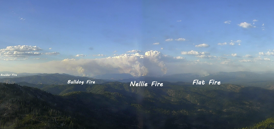
Wapiti Impacts Structures & Nellie Blowup
Yesterday, due to Red Flag conditions, fires were very active across much of Idaho. I won't rehash any of yesterday's mid-day analysis, so go back and check that out for a broader look at things. Today, I will focus on the Wapiti Fire impacting homes/structures in the Grandjean area, the Nellie Fire making a significant run toward Deadwood, and a quick update on the Flat Fire.
Wapiti Fire Impact
4,943 Acres
"Some structures within the Wapati Summer Homes areas were impacted by the fire. Today, firefighters are assessing the impacts of the fire and more information will be made available when available." - Wapiti Fire Update Aug 18, 10am
The Wapiti Fire has been hanging out on the ridge above Grandjean, rather unmotivated to leave the ridge. Most work done on the Wapiti has been to point/structure protection to protect the homes, lodge, and other values in the grandjean area. This generally includes extensive sprinkler systems to keep the area wet and humidities higher, fuel reduction, creating lines between the fire and the structures, creating black along those lines, and other protection methods.
Comparing yesterday's perimeter (and operations map) to today's, it's not apparent exactly how the fire progressed to crossing containment lines and burning into homes; there are two scenarios I can easily see. Both would likely involve a terrain-aligned wind—and we certainly saw lots of wind around Idaho yesterday.
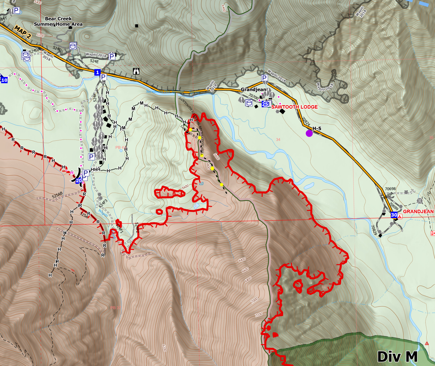
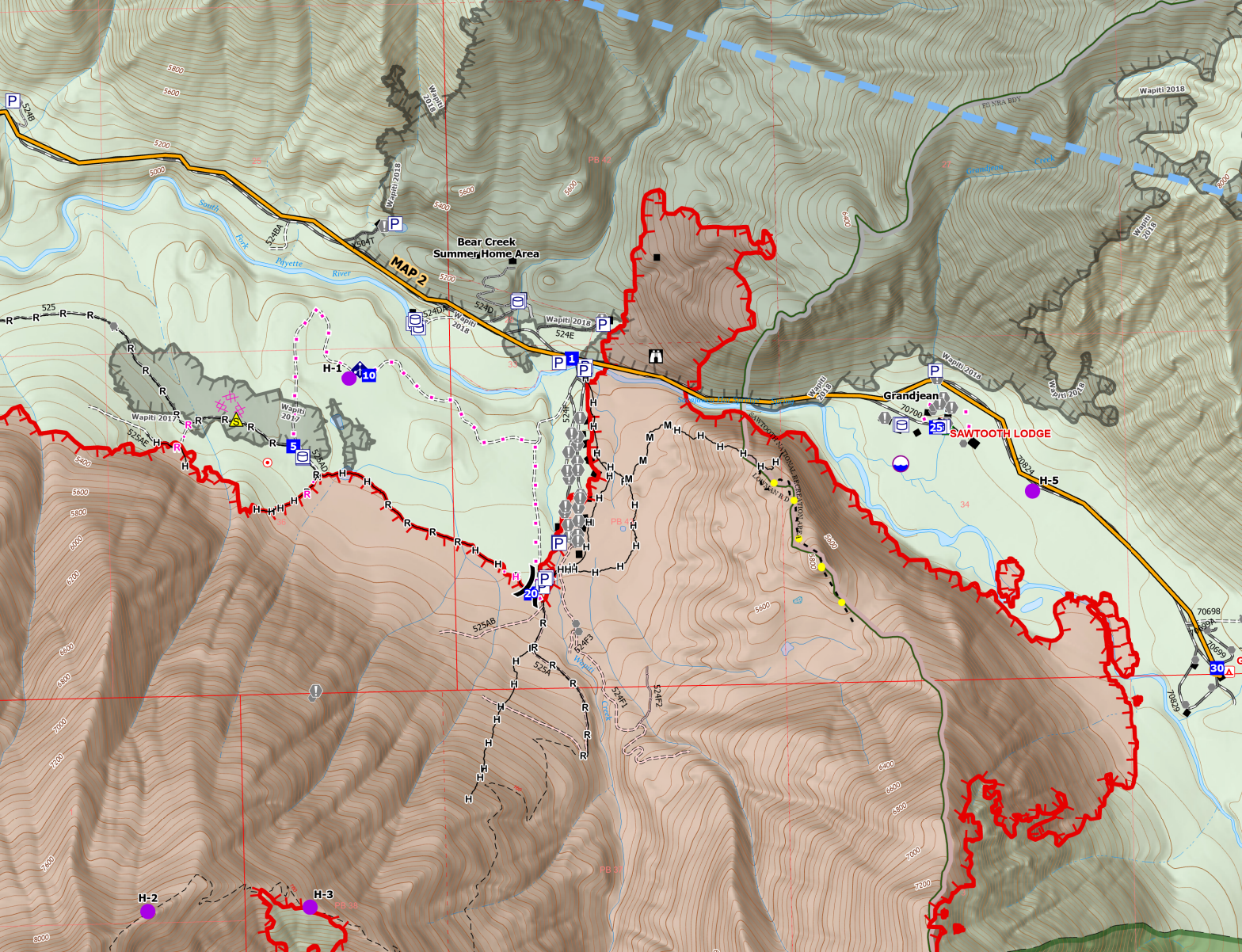
Wapiti Fire Operations Maps (8/17 on the left, 8/18 on the right)
Regardless of exactly which way the fire progressed in its short run, it burned through the Wapiti Summer Homes area, crossing at least one, possibly two, containment lines in the process. It also crossed the road and burned up the hill into the 2018 Wapiti fire perimeter.
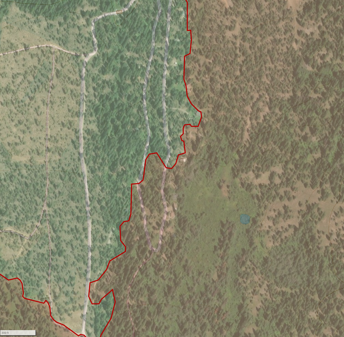
I'm going to show the area where the fire impacted the structures, but let me just reiterate: Just because a structure is within the fire perimeter doesn't mean it burned. Most fires don't burn everything in their path, and fire crews had structure protection in place; the ONLY way to know its true impact is through direct assessment, which will happen as soon as fire crews deem it safe to re-enter the area for assessment. All we know is that some structures were impacted, but not what structures or how badly. I have just seen video of a fire impacting a cabin in the area, and it certainly is concerning, but ultimatly it's inconclusive as the camera was on a tree that burned, not the cabin. In good news, I've not heard of any significant firefighter injuries related to this event.
We will likely have more information on this later today, including details on the fire behavior that caused it.
Nellie
11,273 Acres - 0% Contained
Yesterday, the Nellie Fire had a significant run to the north and a smaller push to the West. Before we dive in, I want to call out a few notes about this fire. First, this fire is currently in monitoring status, which means crews are not actively fighting the fire. However, they are doing point protection to protect resources in the area. In this case, that means Deadwood Lookout, Scott Mountain Lookout, and a communications tower. They are evaluating potential impacts and deploying additional point protection as needed. Second, given how active this fire was and how much of a column it was putting up (see header image at the top of this article), the Satellite-based fire detection maps are going to be less accurate, especially downwind. This is because the satellite sensors can't reliably determine the difference between fire at ground level vs intense heat in a column above and downwind of a fire. What you see on the various fire "apps" and the dots in my map below may not reflect the actual heat perimeter.
Fire crews are also closely monitoring the fire's progression toward Banks-Lowman Road (17). I think the fire will impact Banks-Lowman in the next 5-10 days, but given the fuels and terrain immediately adjacent to the road, I generally believe the road will be held without much trouble. However, we may see it closed for a few days in the process.
Yesterday's fire growth was officially around 4,313 acres. That perimeter is based on an IR flight just after midnight, so the actual growth attributable to yesterday's run will be higher as it burned through the night.
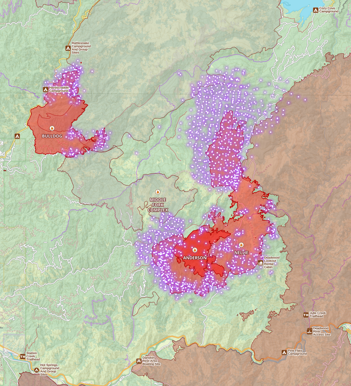
Let me walk you through that map for a moment. First, ignore the "Anderson" fire, which was a separate fire but merged with Nellie. Off to the right, you'll see the (massive) 2016 Pioneer Fire scar. I haven't been in the Deadwood area recently enough to know what the fuel load is in the Pioneer these days, but generally, we won't see the same extreme fire behavior in that old burn as we can see (like yesterday) outside of it. But much of the Pioneer had a mosaic burn pattern, so there will be areas primed to burn, some less likely to burn, and some scorched earth that likely won't support the fire. Long story short, I don't think we'll see a ton of eastward movement, but we could see some in scattered areas.
To the north of the Nellie, you'll see an older, fainter fire perimeter: the 2006 Rattlesnake Complex. Significant chunks of that area were "scorched earth" and haven't seen much growth in the 18 years since. Beyond a few isolated pockets, I don't think we'll see the Nellie getting established in the Rattlesnake Scar moving north.
On the west side, we have the lower portion of the 2006 Rattlesnake Complex, though fuel loads are higher here since the burn was lower intensity in that area. We also have the 2007 Lightning Fire. There appears to be enough fuel in these areas to support westward growth, but not as intense, at least for the northern portion of the fire.
Looking at the south side, as I already said, I do expect this fire to reach the Banks-Loman Canyon in the next week or so. It will be easily held there. My bigger concern is the movement of the south portion to the west. Southwest is not a typical run direction in this part of the state; it'd be a down drainage run, and there's a long way before it impacts anything. I think the odds of impact in that direction are very low, but I'll keep it on my radar.
Flat Fire
3,380 Acres - 14% Contained
Most of my recent updates still apply. The north and west half of the fire is relatively cool, and I'd consider it no longer a threat. The Southeast flank of the fire is where all the activity continues. Yesterday, this area saw numerous tankers working the fire, including multiple SEATs, Scoopers, and a 737 LAT (Large Air Tanker). There's a great video by one of the Single Engine Tanker pilots dropping retardant on the fire here: https://www.facebook.com/share/r/ucZYgT3U9cKddVTD/
The fire was quite active, but the existing lines and additional work by ground and air crews limited fire growth to the southeast. I'm still fairly optimistic about this fire being held with no significant growth east or into the Idaho City Municipal watershed.
Member discussion